Wednesday 11th July 2007
13 miles, 7 hours
The cloud had cleared overnight and we woke to another beautifully sunny day. We left the bed and breakfast at about 9.30 and stopped off the café to pick up supplies before heading back across the footpaths to Westdale Bay.
The redness of the cliffs was really noticeable against the bright blue of the sea.
There were large patches of thrift lining the banks. Unfortunately much of it was past it’s best. A few weeks earlier we would have seen an amazing sight.
The old lighthouse is now disused and has been converted into accommodation. A lovely location and unique place to stay. The replacement has a far less appealing appearance.
From the lighthouse and coastguard buildings the path crosses fields towards Mill Bay. This is the point where Henry Tudor landed in 1485.
It was a perfect day for walking, sunny and warm with a light breeze. As we approached Castlebeach bay we watched a rescue helicopter hovering over Dale point and dropping down to land. When we reached the road we found out that someone had fallen off the cliffs.
Three hours after starting the day we were walking once again through Dale. It was now very busy with people.
The pub looked tempting for a drink but we were a little behind our planned time and we wanted to cross the Gann Estuary before the tide came in so we had to press on.
It was nice to have a change of scenery coming inland.
We had used a tide calculator programme to work out the tides when planning the route several months earlier and were very glad to see it had worked out right.
The Gann estuary was very green and slimy however the bridge was surprisingly clean. From the signpost at Pickleridge carpark it says you have 2 hours either side of low tide. It was nearly three hours past low tide as we crossed and looked like it would still be quite a while before it reached the bridge. 
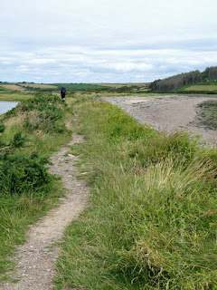
We walked along the beach for as far as possible then took the narrow slightly overgrown path to Monks Haven. The victorian folly on the cliff top above the creek made a good point at which to stop for lunch.
From this point on the path had been strimmed and was far easier going. We passed several large wartime time lookout points and gun emplacements.
By mid afternoon the cloud was building but remained dry. The view ahead was dominated by the oil refineries.
As we approached Great Castle Head a large tanker passed us which we had seen moored out in St Brides bay the previous day.
We reached Sandy Haven at about 4.30pm. The tide was high in the pill but fortunately we didn’t have to cross today, as we were staying at Skerry Back farm. We had a warm welcome, with tea and cake on arrival.
Evening meal: Lift from Mrs Williams to Taberna Inn, Herbrandston. Friendly staff and good range of beer.
Day 8 - Dale to Sandy Haven
Subscribe to:
Post Comments (Atom)
2 comments:
Really great blog. I intend to walk the path in June 2010.
I have a question concerning the Gann, as you write:
"We had used a tide calculator programme to work out the tides". Where can I find this programme?
Thank you.
Haru
Hi Haru,
Thanks for your comment. I think the software we used was WXTide32, which is still available to download from http://www.wxtide32.com/
It includes the Milford Haven tide station which is quite nearby, and should give you good enough timings for being able to cross.
It looked to us as though there would only be problems with quite high tide levels - we crossed 3 hours after low tide (so the tide was coming in) and there was no sign that the causeway would be covered anytime soon.
Post a Comment